


Timelines 10
Man and his Senses 10
Man and his Inventions 10
Geography 10
Fauna 10
Timelines 10
Man and his Senses 10
Man and his Inventions 10
Geography 10
Fauna 10
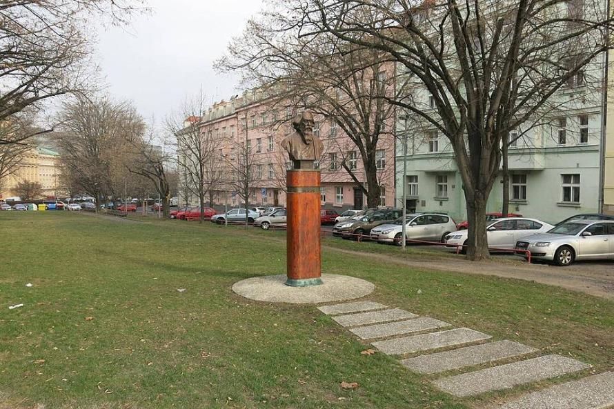
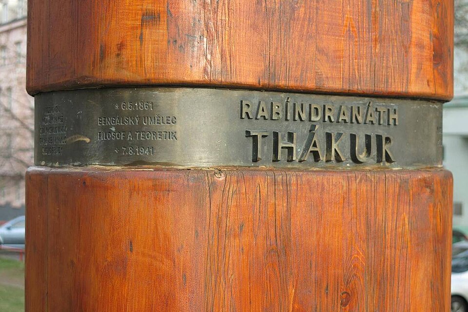
By the end of the nineteenth century streets had already carried more than horse carts and trams; they carried life: markets, conversation, ceremony. Today, as planners and citizens reimagine public space, streets are again being read not as mere conduits for vehicles but as the city’s most shared rooms: places where people meet, vendors trade, children play and local culture shows itself. That shift, from road to room, is visible in small, telling gestures: a bust of Rabindranath Tagore in a Prague park; a widened pavement in Chandigarh; a bustling night market in Ahmedabad. Each gesture is a civic decision that declares, quietly but unmistakably, that human movement, pedestrian spaces and everyday commerce matter as much as traffic flow.
Prague’s Thákurova (Thakurova) is a compact symbol of that civic outlook and of an older cultural exchange. The Dejvice neighbourhood’s Thákurova Park carries a bust of Tagore and a street that bears his name, a public sign of Indo-Czech friendship that has drawn Indian visitors to it, as a place of remembrance. Tagore visited Prague in the 1920s; the memorials and the street name are reminders that the city’s public spaces preserve memory as much as they serve movement. In central Europe, where city centres have long been pedestrianised and squares reclaimed from cars, Thákurova sits comfortably among tree-lined avenues and walkable parks; beyond a lane, it is a statement about how streets can carry identity across borders.
Those European efforts, the slow, deliberate rebalancing of space from engines to people, are part of a wider international trend. Urbanists and practitioners argue that the pedestrian must be the primary user of street space, and that design can nudge behaviour: shared-space streets, curb-free layouts and delineated but unobtrusive parking all slow traffic and make streets easily accessible for people as well as vehicles. The principle is simple and, once applied, very productive: a street designed for people can host markets, festivals and informal recreation as readily as it channels transport. Recent professional writings underline the point: good street design treats the street as a continuous public room, not a broken set of lanes.
Yet the experience of streets in India is shaped by different pressures, rapid urbanisation, high population density and an informal economy that spills onto the pavements. Streets in Indian cities often function simultaneously as transit arteries, marketplaces, eateries and community stages. This is not merely a planning problem to be “fixed”; it is a social condition to be managed and celebrated. A national compendium has documented public space projects that try to do precisely this: reclaim sidewalks, create plazas, integrate street vendors, and design streetscapes that respond to local climates and uses. It stresses that India’s public spaces must balance socio-economic, cultural and environmental values if they are to be inclusive and resilient.
Practical case studies make the point clear. Chandigarh’s Sector 17, the city’s commercial heart, conceived by Le Corbusier’s modern plan, exemplifies wide, tree-lined sidewalks and a central plaza where people hang out. Proposals to make Sector 17 even more pedestrian-centric through limited vehicle access, more cycling tracks and improved public-space treatment, show how legacy plans can be adapted to contemporary needs. On the other hand, in Pune, Fergusson College Road (FC Road) is an example of narrower, more improvised walkability characteristics, with its multipurpose utility, continuous retail frontage and relatively comfortable footpaths. This turns the street into a very lived in, walkable heart through the city. Both examples reveal an Indian “walkable urbanism” that combines design, enforcement and local negotiation to produce space for people.
The Indian city of Ahmedabad supplies yet another lesson, this time about the street as an engine of urban livelihoods. Detailed fieldwork on street vending there shows how vendors are embedded in the city’s economic geography: they respond to land use, time of day and pedestrian flows, and they supply affordable goods and services to a wide cross-section of citizens. Far from being a marginal problem, street vending is a central organizing force for public life in many Indian cities; it is also a design challenge. Studies that map thousands of vendors across time slices show that policy interventions must be evidence-based and specific to the context. Vendor formalisation, designated vending zones, and infrastructure support can both preserve livelihoods and free up pedestrian space for walking and for childrens' play areas. Ahmedabad’s experience, being rich, contested and adaptive, has become a guide for understanding streets as multifunctional public spaces.
What, then, do designers and civic leaders have at hand? The playbook is familiar: wide, well-maintained sidewalks; clear crossings; mixed land use; trees and shade; and spaces for vending and social life, but its application must be local. In Europe, a shared-space sensibility often begins with traffic controls and a cultural expectation of pedestrian priority. In India it requires both design and governance: negotiated vending zones, active management of encroachment, and small interventions that let commerce, vehicular traffic and walking coexist. Practitioners point to incremental tactics, including tactical urbanism, plaza pilots and market relocations with design upgrades, as the practical route to more walkable, liveable streets.
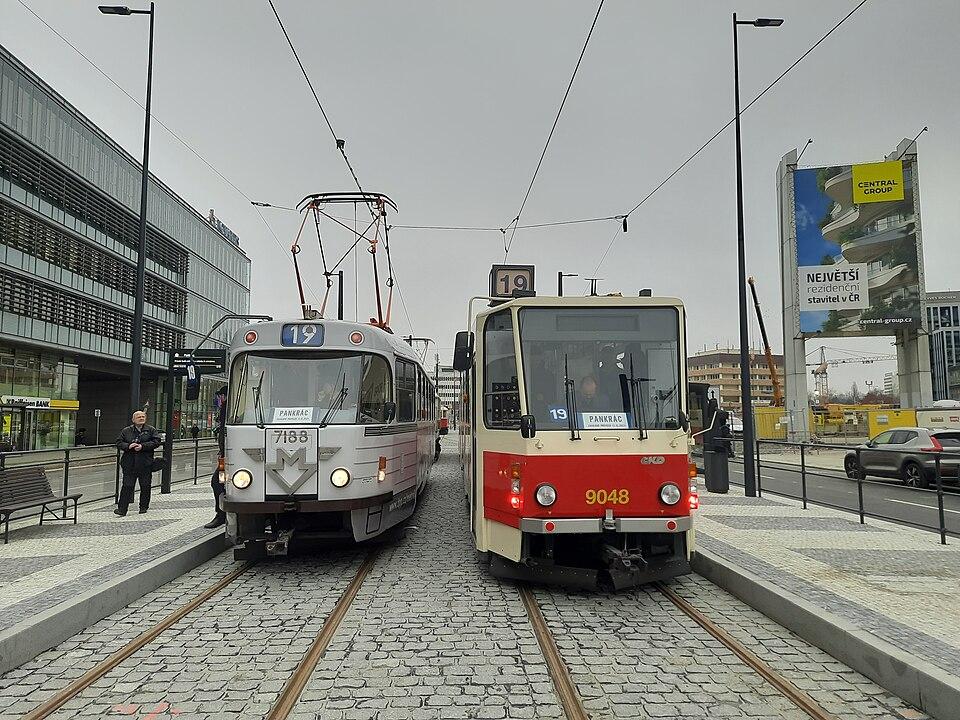
Taking the example of Prague, we can see that Tram and metro services have very effectively reduced dependence on cars, and have minimized congestion so that overground surface space can be prioritized for wider sidewalks, shade, crossings, and everyday street life. Integrated operations under one fare/pass make transfers seamless across tram, metro, and bus, which encourages the shift away from private cars and supports “people-first streets”. Prague’s fare and boarding “software” (proof-of-payment, simple validation, and low-friction access) speeds vehicles and embeds transit into daily life, further aligning mobility with pedestrian comfort.
Prague's transport network facts
Prague's tramway is one of Europe’s most extensive surface systems, with 144 km of track, a large fleet, and service patterns that include day and night service, and historic lines integrated within it as well. The metro caters to longer trips across the city and towards its suburbs.
Fare and operations
One fare system covers trams, metro, and buses under a proof‑of‑payment system, enabling fast, all-door boarding without turnstiles, supported by randomized inspections and fines for fare evasion. Pricing structures emphasize affordable long-term passes for residents alongside higher short-term tickets, encouraging habitual transit use and cutting unnecessary car trips. Basic single tickets and season options exist within the PID system, with documented concessions for younger riders and seniors, reinforcing affordability and access across modes.
Organizing street space
Prague increasingly prioritizes trams on dedicated or protected alignments and gives them preference at street level, which organizes surface movement and reduces interference from general traffic. As more trips shift to trams and the metro, the share of daily public-transport users remains high, supporting smooth corridors where pedestrian activity and local commerce can thrive.
Tram vs metro roles
Trams offer fine-grained, street-level access with closer stop spacing that supports short urban trips and active street life, whereas metros provide higher capacity and speed along straighter, grade-separated corridors for longer movements. In Prague, deep-tunnel metro lines built in the 1970s complement the surface tram grid by serving longer regional trips with wider stop spacing, while trams maintain a visible presence that integrates directly with sidewalks and squares. The practical approach is not “either/or” but network complementarity. Metros carry heavy through-demand while trams structure walkable corridors in between, collectively reducing the need for car space.
Quality and recognition
Prague’s system ranks second worldwide in a recent Time Out survey, with 96% of locals reporting it’s easy to get around, citing convenience, speed, reliability, affordability, and environmental benefits. More than half of residents use public transport daily versus about one-fifth who use a car daily, a pattern consistent with reallocating street priority toward people rather than vehicle throughput.
Streets are framed as civic “rooms” that host memory, markets, and everyday life, illustrated by Prague’s Thákurova and Indian examples like Chandigarh, Pune, and Ahmedabad where design and governance balance pedestrian zones with commerce. The argument favors people-first street design—wide sidewalks, shade, shared spaces, vendor integration—adapted to local conditions, with incremental tactics like tactical urbanism and plaza pilots. Tying in Locomotion, Prague’s frequent trams and complementary metro reduce car dependence through integrated fares and proof‑of‑payment, organizing surface space for pedestrians and vendors, offering a complementary network associated with high public‑transport use and recognized quality.
Sources:
https://tinyurl.com/28u9vfqx
https://tinyurl.com/29mldxwm
https://tinyurl.com/2ar7xrb5
https://tinyurl.com/24f37jmh
https://tinyurl.com/23eb538b
https://tinyurl.com/2awrn82h
https://tinyurl.com/23yzd3kt
https://tinyurl.com/2ar4c9n2